Rare ‘super El Niño’ spikes ocean temps to new record
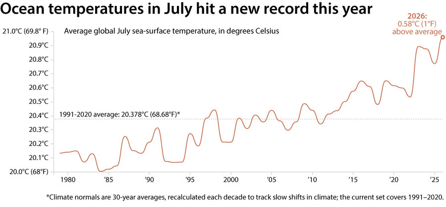
Ocean surface temperatures in July were the hottest ever recorded, the European Union’s Copernicus climate monitoring service announced Monday. Monitoring stations in the non-polar ocean captured an average temperature of 20.96 degrees Celsius (or 69.73 degrees Fahrenheit). It surpasses the record set in 2023.
This monthly ocean temperature record is just one of many weather anomalies that the world will see this year, say climate scientists, as a rare “super El Niño” upends air and ocean temperatures around the globe.
El Niños are natural climate phenomena that occur every 2 to 7 years when the normally predictable trade winds that blow east to west over the equator slow down. These winds typically push warm surface water with them to the western Pacific ocean around Asia and Australia, which then allows colder, deeper water to rise to the surface in the eastern Pacific, around the Americas. But when the winds slow down, the warm water that’s typically pushed west can slide back east, spreading the warm water across a greater share of the ocean.
Why We Wrote This
Oceans are already unusually warm because of climate change, scientists say. Now, a rare “super El Niño” has pushed ocean surface temperatures to their highest July levels in recorded history. Scientists expect the phenomenon to upend air and ocean temperatures around the globe.
Scientists say climate change has been increasing the world’s ocean temperatures over the past few decades. While there is a scientific debate about how global warming affects the strength or frequency of El Niños themselves, researchers generally agree that these events are taking place on a baseline affected by climate change: warmer oceans, an atmosphere that is hotter, and, depending on the place, either increased drought or increased atmospheric moisture. This July also tied with 2024 for the second-warmest air temperatures, according to the European Union’s Copernicus, behind the record set in 2023.
 SOURCE:
Copernicus Climate Change Service
In the United States, the National Oceanic and Atmospheric Administration (NOAA) declares it an El Niño year when surface temperatures in the central and eastern tropical Pacific Ocean warm 0.5 degrees Celsius (or 0.9 degrees Fahrenheit) above normal. According to the NOAA, there is more than an 80% chance a “very strong El Niño” will occur at the end of this year, which “would rank among the largest El Niño events in the historical record going back to 1950,” according to NOAA’s Climate Prediction Center.
While changes of 1 or 2 degrees in ocean temperatures may not seem like a lot, they can be enough to affect fragile oceanic ecosystems. During prior “super El Niño” years – 1982-83, 1997-98, and 2015-16 – scientists chronicled mass coral bleaching and “bottom-up” cascading effects: phytoplankton declines with the loss of colder, nutrient-rich waters, which leads to less food for fish and seabirds.
Deepen your worldview
with Monitor Highlights.
Already a subscriber? Log in to hide ads.
Humans are also likely to experience dramatic El Niño-triggered events on land, as the shifting ocean temperatures change typical atmospheric patterns. Increased droughts are expected off the western Pacific, as more floods and hurricanes roil the eastern Pacific. But specifics are difficult to predict.
“Every El Niño is not the same,” said Ken Graham, director of NOAA’s National Weather Service. “Each one is unique with its own imprint on our weather.”